Staring at a listing that says “Sound front” or “Bay views” and wondering what that really means for your lifestyle and budget? If you are shopping or selling around Gulf Breeze and greater Escambia County, the water type matters more than you might think. It affects boating access, dock options, flood risk, permits, insurance, and resale. This guide breaks down bay, sound, and canal terms in plain language and shows how each plays out locally so you can buy or sell with confidence. Let’s dive in.
Gulf, bay, sound, canal: what they mean here
Gulf frontage
Gulffront homes sit on the open Gulf of Mexico. You get big-water views and direct exposure to wind, waves, and storm surge. Docking can be more complex and expensive due to higher wave energy. Around the Pensacola area, Gulffront is less common than bay or sound frontage for primary residences.
Bay frontage
Bayfront faces a semi-enclosed waterbody connected to the Gulf, such as Pensacola Bay. Bays tend to be larger and often have deeper navigational channels used by commercial and recreational boats. You typically see moderate wave action, excellent inshore boating, and a balance between views and protection.
Sound frontage
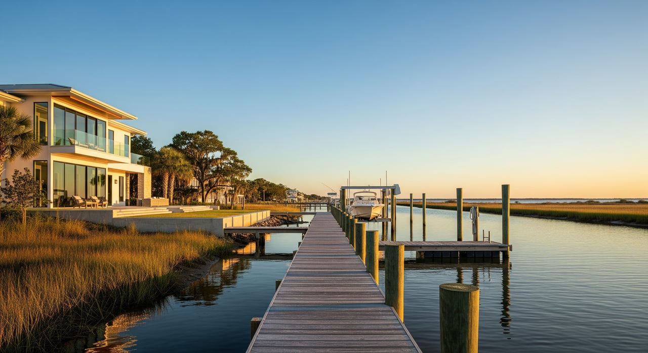
Sound-front homes face a relatively narrow corridor between the mainland and barrier islands. Locally, that is the Santa Rosa Sound along the Fairpoint Peninsula where Gulf Breeze sits. The Gulf Intracoastal Waterway runs this route, creating a popular boating corridor with marked channels and bridge crossings. Waters are generally calmer than the open Gulf.
Canal frontage
Canal homes sit on man-made residential canals cut off a bay or the sound. Canals provide protected moorage and easy dockage. Depth and width can limit boat size, and some canals may require periodic dredging. Wakes are usually lighter than in open water, though boat traffic can still affect shorelines.
How waterfront type affects your day-to-day
Boating access and navigation
If boating is your priority, study your path to the Intracoastal and the Gulf. Sound and bay locations often offer quick access to the Gulf Intracoastal Waterway and marked channels. Canals provide convenience for docking but may add travel time or draft limits. Always confirm channel depths, bridge clearances, and tides for your boat. For planning, review local tide data through NOAA Tides and Currents and consult official NOAA nautical charts.
Wave, tide, and storm exposure
The northern Gulf is microtidal, with typical tide ranges around 1 to 2 feet. That small range still affects dock heights, lift choices, and shallow-water access. Gulffront and some bayfront properties feel higher wave energy and may see greater storm-surge exposure. Sounds can channel surge depending on local geometry, while canals may concentrate inland flooding in extreme events.
Water quality and habitats
Local waters range from marine to brackish, and you may see seagrass beds, oyster reefs, or salt marsh nearby. These habitats support fisheries and improve water clarity, and they are also regulated. Disturbing seagrass or oyster areas for docks or shoreline projects can require permits and mitigation. For habitat context and best practices, explore guidance from the Florida Fish and Wildlife Conservation Commission and project requirements through the Florida Department of Environmental Protection.
Docks, seawalls, and permits
Building or modifying a dock, boat lift, seawall, or living shoreline is not a one-agency decision. You may need approvals at multiple levels:
- Local: Check zoning, setbacks, and building permits with Escambia County Permitting and Building Services or the City of Gulf Breeze Planning and Building department.
- State: The Florida Department of Environmental Protection oversees activities on sovereign submerged lands and protects seagrass and oyster resources.
- Federal: The U.S. Army Corps of Engineers Regulatory Program covers work in navigable waters and wetlands.
Feasibility comes down to water depth at mean low water, habitat presence, and setbacks. Where feasible, living shorelines are increasingly encouraged to reduce erosion and support habitat. Any structure must meet wind and coastal provisions of the Florida Building Code, especially in coastal high-hazard zones.
Flood, wind, and insurance
Waterfront parcels often lie in FEMA Special Flood Hazard Areas. Your flood zone affects mortgage requirements, building elevations, and premiums. Before you make an offer, check the site on the FEMA Flood Map Service Center and request an elevation certificate if available. Coastal homes also face higher wind exposure, so plan for windstorm coverage and mitigation features under the Florida Building Code. The insurance market is dynamic in Florida. Obtain quotes early from private carriers or the state-backed Citizens Property Insurance Corporation to understand your budget.
Utilities and upkeep
Verify whether the home is on municipal sewer or a permitted septic system. In low-lying areas, sea level and drainage can affect septic performance and long-term maintenance. Ask for records of any shoreline work, including seawalls, bulkheads, and dredging assessments. In canal communities, find out who maintains the canal and how dredging costs are shared.
Pricing and resale considerations
Different waterfront types attract different buyers. Gulffront commands a premium for views and direct Gulf access. Sound and bayfront often appeal to boaters and families who want calmer waters and a quick route to the Intracoastal. Canal lots can offer strong value for private dockage and protected moorage, subject to depth limits. For resale, complete disclosure matters. Share permits, elevation data, insurance history, shoreline maintenance, and any HOA or dredging assessments. Seasonal water quality, storm history, and evolving regulations can also influence value over time.
Buyer and seller due diligence checklist
Use this simple checklist to reduce risk and surprises:
- Confirm the waterfront type
- Review the deed, survey, or plat. Visit at high and low tide to observe water levels, wakes, and traffic.
- Verify boat access
- Check channel depth, bridge clearances, and proximity to the GIWW. Use NOAA nautical charts and NOAA Tides and Currents.
- Gather permits and approvals
- Request all dock, lift, seawall, and dredging permits from the seller. Confirm with Escambia County Permitting and Building, the City of Gulf Breeze, FDEP, and the USACE Regulatory Program.
- Assess flood and storm risk
- Look up the parcel on the FEMA Flood Map Service Center and request an elevation certificate. Ask about storm history and any V Zone requirements.
- Price insurance early
- Obtain quotes for homeowners, flood, and windstorm coverage, including options through Citizens Property Insurance Corporation.
- Check environmental constraints
- Ask about nearby seagrass, oyster beds, or salt marsh that could affect dock placement or require mitigation. Review guidance with FDEP and habitat info from FWC.
- Confirm utilities
- Verify sewer connection. If septic, obtain permits and inspection records.
- Understand maintenance and HOA rules
- Request HOA or BOA covenants and any special assessments for dredging, seawalls, or shared infrastructure.
- Weigh long-term risks
- Consider sea level rise, canal dredging cycles, and future maintenance obligations when budgeting.
- Hire the right specialists
- Engage a licensed home inspector, marine or coastal engineer, land surveyor, a real estate attorney for title and easements, and an insurance broker familiar with coastal risks.
Local resources you will use
- Escambia County Permitting and Building Services for permits and floodplain guidance: Escambia County
- City of Gulf Breeze Planning and Building for local approvals: City of Gulf Breeze
- FEMA Flood Map Service Center for flood zones and FIRMs: FEMA maps
- NOAA for tides and navigation planning: NOAA Tides and Currents and NOAA charts
- U.S. Army Corps of Engineers for federal waterfront permitting: USACE Regulatory Program
- Florida Department of Environmental Protection for submerged lands and coastal structures: FDEP
- Florida Building Code for coastal construction standards: Florida Building Code
- Citizens Property Insurance for state-backed coverage details: Citizens
The bottom line
In the Gulf Breeze area, the words bay, sound, and canal are more than listing buzzwords. They shape your boating lifestyle, dock options, flood and wind exposure, insurance costs, and long-term maintenance. By matching the waterfront type to your goals and doing careful due diligence on permits, elevation, and access, you can buy with clarity and sell with confidence.
If you want tailored guidance on a specific property or prep for a sale, reach out to Avenue Realty to schedule a Free Home Consultation. Our team pairs local waterfront expertise with hands-on service to help you move forward with certainty.
FAQs
What is the difference between bayfront and sound-front in Gulf Breeze?
- Bayfront faces larger semi-enclosed waters like Pensacola Bay with deeper channels, while sound-front faces the narrower Santa Rosa Sound with calmer water and direct access to the Intracoastal corridor.
Do canals in Gulf Breeze handle larger boats?
- Many canals offer protected dockage but can have width and depth limits that restrict boat size, so verify draft and recent dredging records before you buy.
How do I check if a dock is permitted on a property?
- Ask the seller for permit records and confirm with Escambia County, the City of Gulf Breeze, FDEP, and the USACE Regulatory Program.
How do I find my flood zone and elevation for insurance?
- Look up the address on the FEMA Flood Map Service Center and request an elevation certificate to understand requirements and premium impacts.
Who regulates seagrass and oyster protections near docks?
- The Florida Department of Environmental Protection and the U.S. Army Corps of Engineers review projects that might affect protected habitats, with input from state habitat agencies.
Where can I confirm bridge clearances and tide ranges for my boat?
- Use official NOAA Tides and Currents for tide data and check NOAA nautical charts for bridge clearances and marked channels.